


February in New York City is usually a month of bitter cold and blasts of snow, but not this year.
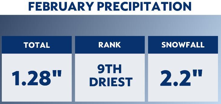
To get snow during the winter, you need a few factors. The first is moisture, and we just didn't get it this past February. Total precipitation for the month was less than an inch-and-a-half. That ranks as the ninth-driest February in over 150 years for our city.
We had two snow events in the month, but neither one was very impactful. The greatest snowfall was 2.2 inches, which occurred on the last two days of the month. The average snowfall for February is 10 inches.
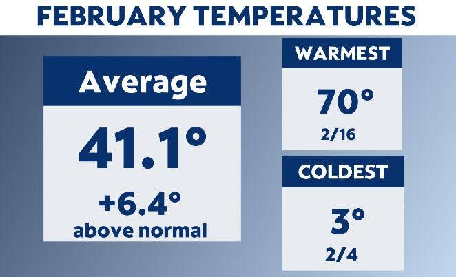
The other element needed for snowfall is cold temperatures, and we didn't see much of that, either. We did have a quick cold shot with a low of temperature of 3 degrees on Feb. 4. That was the coldest reading in the city in three years.
Despite that short cold blast, Feb. 2023 overall was very warm. Temperatures got to 50 degrees or warmer 13 times. We hit 60 degrees or more five times, and the top temperature for the month was 70 degrees.
Overall, the month ranked as the third-warmest. For much of the month, readings were more typical of early April and plants began to bloom with some cherry blossoms popping out.
So, why was February so warm and dry? It was because of a jet stream pattern that was persistent for much of the month.
The winds in the upper atmosphere that steer storms and air masses keep the cold and storms mainly on the West Coast. In the East, we had what is known as a ridge in the jet stream. This is when the jet stream arches up. Typically, areas under this ridge are dry and warmer than average.
Was the warm and dry weather related to climate change? Not really. Climate change is measured in decades, not just weeks. The most likely reason for the warm and dry pattern was La Niña.
This weather phenomenon happens when water is cooler than average off the west coast of equatorial South America. It often brings warm temperatures to our area in the winter months. This was the third consecutive winter with La Niña conditions.

Our team of meteorologists dives deep into the science of weather and breaks down timely weather data and information. To view more weather and climate stories, check out our weather blogs section.