


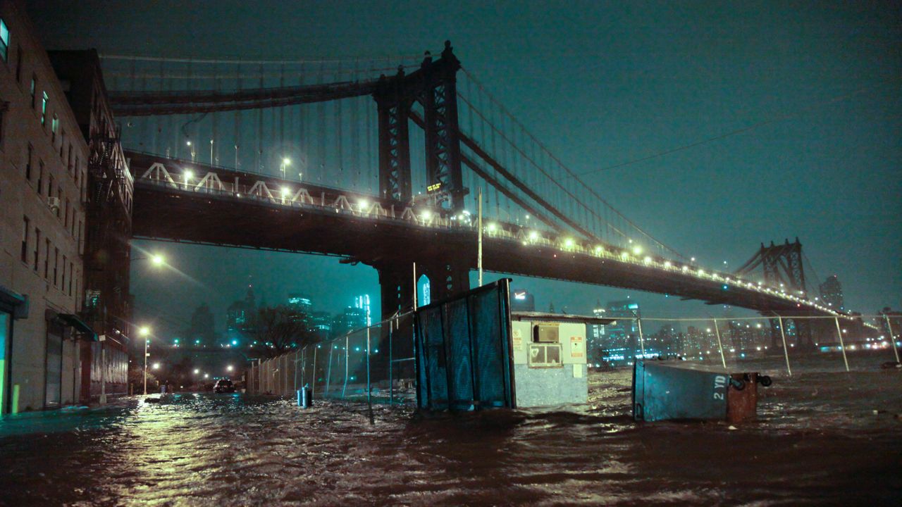
In 1856, New York City began monitoring an important weather feature for the benefit of ships coming and going from the harbor: the height of the tide, and its change over the day and through the seasons.
Today, that enormous data set, comprising more than a century and a half of measurements, serves a purpose never intended for it. It is the backbone of scientific efforts to predict flooding and the effects of sea level rise caused by climate change.
The federal government incorporates the data into two sets of maps currently in development by the Federal Emergency Management Agency and the city, one showing current and the other showing future flood risk for coastal parts of the five boroughs.
Both maps will have a significant impact when released. FEMA’s map of current flood risk — its last preliminary map was released in 2015 — could show that thousands of more residents are in the flood zone, in many cases requiring them to pay for flood insurance. And the de Blasio administration is planning for the city’s future flood risk map to be incorporated into the building code, meaning that the map will shape development in flood-prone areas.
The maps, with the city’s set to be released next year and FEMA’s in 2024, are coming at a key time. Scientists say that it is no coincidence that this year has already brought unthinkable weather crises to New York City, first with rainstorm-caused flash flooding in hilly parts of the city and then with smoke from wildfires across the continent filling the air: Climate change appears to be speeding up.
“We’re beginning to approach a turning point within the next couple of decades,” said Vivien Gornitz, a researcher with the Columbia Center for Climate Systems Research and a former member of the New York City Panel on Climate Change. “We’re starting to move onto that exponential curve.”
New York City has been doing as much work as any American city to map its flood risks. The NPCC in 2019 released a set of flood maps that showed sea level elevation and flood risk into 2100, including estimates for how coastal neighborhoods would be inundated if the West Antarctic Ice Sheet rapidly destabilized, catastrophically speeding up global sea level rise. In May, the city released a map that combined coastal flood risk with stormwater flood risk, which showed potential flash flood areas across the city by the middle of the century.
Yet the city has not officially included these maps in planning rules, even as City Hall says it uses the maps to inform current infrastructure projects.
“The more accurate understanding we have of where it’s likely to flood, the better we can prioritize investments to build resiliency to protect against flooding,” said Timon McPhearson, an associate professor of urban ecology at The New School.
As FEMA prepares its flood insurance maps, the city is using the feds’ computer model for visualizing flood risk — created using the 165 years of tide gauge data — and projecting it into the future, using the NPCC’s estimates of local sea level rise into the second half of the 21st century.
Since FEMA models current flood risks across the country, this approach could be exported to other coastal metropolitan areas: take the federal government’s powerful computer model and use local flooding projections to paint a picture of what climate change may have in store. If done right, it could eliminate competing flood risk maps from private and academic sources and create a partnership between university scientists, city governments and FEMA.
“As long as this process brings in academic science, and I think that's their goal, then everyone is in the room together trying to make the best possible product,” said Phil Orton, a research associate professor at the Stevens Institute of Technology and a member of the NPCC. Orton and Gornitz were co-authors on the report that included the NPCC’s 2019 maps, which pioneered the city’s current mapping technique.
The city received a $750,000 grant from FEMA to create the future flood risk maps, which the city has said it will release in 2022. The contractor selected to create the maps, Michael Baker Engineering, is set to start on the work before the end of the summer.
The maps — both the city’s and FEMA’s — will likely have stark economic and social effects, McPhearson said. A 2020 paper co-authored by McPhearson with several other New School colleagues showed that neighborhoods in high-risk flood zones are even denser than they were before Superstorm Sandy in 2012.
“The city’s work with FEMA to try to get the floodplain correct is really important, because it has all of these potential impacts on both low- and high-income communities,” McPhearson said.
Yet researchers are concerned that without robust outreach efforts residents may not understand the differences between the federal and city maps. A resident of Canarsie, for instance, may not need flood insurance based on the FEMA map, yet could still see their house in the floodplain described by the city’s map for the year 2040.
In an email, Phil Ortiz, a spokesperson for the Mayor’s Office of Climate Resiliency, said the city “will continue promoting flood risk awareness, including by holding informational workshops in high-risk neighborhoods, holding briefings for elected officials, and working with” nonprofits. FEMA is launching a $1 million ad campaign to encourage New Yorker’s in flood-prone areas to buy flood insurance ahead of this year’s hurricane season.
What will remain unclear until the maps are released, and for some time after, is how they affect development in areas that show up with a high likelihood of monthly flooding. Even though residents have flocked to high-risk areas like Coney Island and the Rockaways, changing building requirements for those areas based on the new maps could shut down new development or make it difficult for people to sell homes that need updates to be protected from flooding. A dramatically expanded flood insurance map from FEMA could add costly premiums to many families’ bottom lines.
It is part of the difficult trade-off of resiliency planning, McPhearson said. On the one hand, you need to be as clear-eyed as possible about how severe the effects of climate change will be, and where.
“And yet what we don't want to do is place economic burdens that are very difficult for people to deal with, especially when they may not see the worst case scenario in their lifetimes,” he said. “We’re not talking about thousands of people that this will impact. We’re talking about hundreds of thousands.”