


Cold weather is back in North Carolina, and another chance of snow is possible by the middle of this week. However, any snow accumulation in central North Carolina this week should be fairly light.
A front moving from west to east across the state from late Tuesday night through Wednesday will produce the light snow showers. These type of weather systems usually don't have much moisture after crossing the North Carolina mountains. At times, the precipitation can dry up all together once a front like this crosses the mountains. However, computer forecast models are in fairly good agreement that at least some light precipitation will fall Wednesday in central North Carolina.
While the exact timing is still a bit uncertain, it appears the light precipitation would start in the region before sunrise Wednesday morning. It should fall mainly as light snow from Raleigh to the north and northwest, but light sprinkles of rain could be mixed in initially. South and southeast of Raleigh including around Fayetteville, there is a somewhat higher chance that the precipitation will fall as a light rain and snow mix. Any precipitation should come to an end by the afternoon.
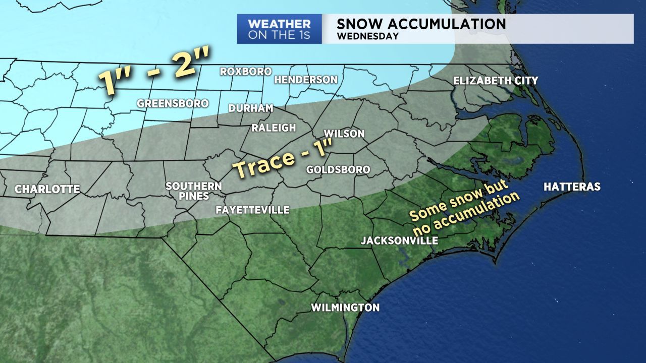
Early indications suggest one to two inches of snow will be possible north and northwest of Raleigh including around Durham, Chapel Hill, Roxboro, Henderson and Roanoke Rapids. From near Raleigh to the south and southeast, a dusting to inch is possible. This would include Southern Pines, Smithfield, Wilson and Goldsboro. Areas near and south of Fayetteville may see very little if any accumulation at all because the precipitation will likely be even lighter in these areas.
Even these light amounts of snow could be enough to create hazardous travel conditions on roads around the region as early as the morning commute Wednesday. Those conditions may improve somewhat if the precipitation ends early enough in the afternoon Wednesday with temperatures slightly above freezing. However, anything left on the ground and roads would freeze Wednesday night as temperatures drop to the upper teens by early Thursday morning.
Since Wednesday's front is still a couple days away from North Carolina, the exact timing and amounts of precipitation forecast could still change. Stay tuned to Weather on the 1s on Spectrum News for updates on the forecast.